ALL ABOUT THE MAKALU EXTREME EXPEDITION TO SUMMIT OF K2- 8611- 2021
All about K2- 8611 expedition
This offer is for those who love High Mountains and do not change their life course in any circumstances! Join the expedition of mountaineering experts! Expedition guides Dorchi Sherpa- climed 2 times on the Top of K2, Pasang Lama- climed the Top of K2, and was able to go down himself and helped his client to go down on K2 disaster in 2008. Thus, by joining our company, you put your life in safe hands. We also want to draw Your attention to the fact that using the services of guides without proper experience on this Mountain is life-threatening, and 100% leads to disaster. When choosing an operator for this tour, choose only those who have already Summit K2, preferably more than once
At this difficult time, we invite You to an expedition that will 100% take place. Based on the results of conversation with the Embassy of Pakistan in Moscow, I can inform you that entry to the country for mountaineering expeditions is open for foreigners and citizens of Nepal. There is also the availability of flights and tickets Istanbul - Islamabad – Istanbul. The cost of one ticket is 700 US dollars.
K2- 8611, SHORT INFORMATION
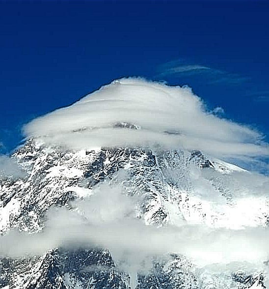
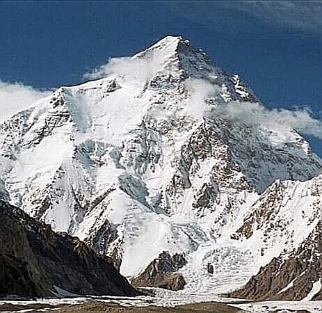
K2-8611 or Chogori, Godwin-Osten in Urdu, Dapsang in Hindi — the second highest mountain peak on Earth (after Everest). The northernmost eight-thousandth mountain in the world and the most difficult Mountain on Earth, the Mountain of Mountains, as mountaineers say. It is located in the Baltoro range on the border of Kashmir (the Northern territories controlled by Pakistan) and the Xinjiang Uygur Autonomous region of China, in the Karakoram mountain system Northwest of the Himalayas.
K2 or Chogori is known as "savage Mountain" because of the extreme difficulty of climbing. As of June 2020, the death rate was 22% for 369 ascent attempts. It is more difficult and dangerous to reach the summit of K2 from the Chinese side, so it is usually climbed from the Pakistani side. K2 has never been climbed in winter, unlike all other eight-thousand-meter mountains. Ascents were almost always made in July and August, the warmest months of the year; K2's more northerly location makes it more susceptible to inclement and cold weather.
Chogori was discovered by a European expedition in 1856. The mountain was designated " K2 " as the second peak of Karakoram. The peaks designated K1, K3, K4, and K5 were later renamed and are now called Masherbrum, Gasherbrum IV, Gasherbrum II, and Gasherbrum I, respectively. Historically, the technical name K2 has remained the most well-known in Europe.
The first attempt to climb Mount K2 was made in 1902 by Oscar Eckenstein and Aleister Crowley,but failed. Due to stormy weather, they were not even able to start climbing, but the heroes collected a large amount of useful information about the upper reaches of the Godwin-Austen glacier, which served for the benefit of subsequent expeditions. 7 years later, the team of the Duke of Abruzzi attempted to climb K2 and made a reconnaissance of the South-Eastern ridge, but stopped at 5560. A significant breakthrough was the expedition of American mountaineers in 1938, and their ascent to an altitude of 7925 m. Eight intermediate camps were set up, but again something went wrong. A year later, the Americans again reached the 8382 mark, but on the way back they found that all the intermediate camps up to camp 2 were abandoned. Tragically, Dudley wolf and three Sherpas who went in search of him were killed. Prior to climbing K2, three American expeditions had unsuccessfully attempted to reach K2, most recently in 1953 under the leadership of Dr. Charles Houston.
The first to reach the top of K2 was an Italian expedition in 1954 led by Ardito Desio. On July 31, Italian climbers Lino Lacedelli and Achille Compagnoni were the first to reach the summit of K2. For the ascent, the Italians used the South-Eastern "Abruzzi rib", which is now the most popular route for climbing K2 (it is used by up to three-quarters of climbers who climb K2.)
The first woman to climb K2 was Polish mountaineer Wanda Rutkiewicz (1986)
The American expedition "K-2" on March 6, 1987 reported that according to satellite measurements, the height of the mountain is in the range from 8858 to 8908 m, thus it is the highest in the world. On August 13, 1987, these measurements were refuted by Chinese topographers, who determined the height of mount Everest as 8848 meters, and K2 as 8611 meters.
For the first time in the history of the former Soviet Union, Vladimir Balyberdin (Russia) and Gennady Kopeyka (Ukraine) reached the summit on August 1, 1992, and Alexey Nikiforov (Russia) on August 3, 1992, as part of an international expedition led by Balyberdin.
As of 2015, there are 10 different routes to the top of K2.
The most mass ascent to the summit in the history of its conquest took place on July 22-23, 2018, when 63 climbers who were clients of commercial expeditions climbed the peak in perfect weather, of which one died, becoming the 85th victim of the mountain.
July 22, 2018 - Polish mountaineer Andrzej Bargel (Polish. Andrzej Bargiel) became the first person in the world to descend from the top of K2 on mountain skis.
ALL ABOUT THE MAKALU EXTREME EXPEDITION TO SUMMIT OF K2- 8611- 2021
Day 1. Our expedition to K2 starts in Islamabad, capital of Pakistan. Here, at the international airport of Islamabad, we meet our participants on private transport. In the hands of the greeter, the unchanging banner Makalu Extreme. Check in to the hotel. The hotel is very clean, equipped with comfortable bathrooms, air conditioning, glasses for drinking water.
ISLAMABAD, QUICK REFERENCE
Islamabad is the capital of the Islamic Republic of Pakistan. Built in the 1960s as a planned city to replace Karachi as the capital of Pakistan. Cultural, political and economic center of the country. Islamabad is known for its high standard of living, security, and abundant vegetation.
According to the census of 2017, the city's population is 1 014 825 people. Islamabad is the 9th largest city in Pakistan, while the larger metropolis of Islamabad-Rawalpindi is the third largest in the country with a population of more than four million people.
Islamabad is located on the Potohar plateau in the North-Eastern part of the country, between the Rawalpindi district and the Margalla hills national Park in the North. Historically, this region was part of the crossroads of Punjab and Khyber Pakhtunkhwa with the Margalla pass acting as a gateway between the two regions.
The city's master plan, designed by Greek architect Konstantinos Apostolou Doxiadis, divides the city into eight zones, including administrative, diplomatic enclave, residential areas, educational sectors, industrial sectors, commercial areas, and rural and green areas. The city is known for the presence of several parks and forests, including the national Park Margalla hills and Park Shakarparian. The city is home to several attractions, including the Faisal mosque, the largest mosque in South Asia and the fourth largest in the world. Other attractions include the Pakistan monument and Democracy square.
Islamabad is a global city; it is classified as a city with a very high human development index, with an HDI of 0.875, the second largest in the country after Lahore. The city has the highest cost of living in Pakistan, and its population is dominated by middle-and upper-middle-class citizens. There are more than twenty universities in the city, including Bahir University, qaid-I Azam University, Pakistan Institute of engineering and applied Sciences, COMSATS University, and national University of science and technology. The city is one of the safest in Pakistan and has an extensive surveillance system with 1,900 CCTV cameras.
The capital of Pakistan is located near the North-Western outskirts of the Himalayas, on the Potwar plateau. To the North of Islamabad is the largest mountain junction of Asia and the whole world, the intersection of the ranges-the Hindu Kush, Pamir, Karakoram. The Himalayas stretch East of the city. The Indus river flows West of Islamabad. The city center is located at an altitude of 507 m above sea level
The climate of Islamabad is subtropical, which is strongly influenced by seasonal winds — monsoons, as well as the foothill location. Islamabad is located in a zone of moderate humidity, which is rare for Pakistan, as many areas of the country suffer from arid climate. During the year, up to 900 mm of precipitation falls in the area of the capital. The warmest month in Islamabad is June (not July or August). The reason for this is the onset of the monsoon in July and August, when heavy precipitation falls, and the average temperature decreases. The average temperature in June is +31.3 °C. The coldest month is January, with an average temperature of +10.2 °C. Warm days and cold nights are typical, with occasional frosts in the winter months, although they are quite rare; sometimes snow falls, although also infrequently.
Islamabad is a multi-ethnic city. The official language is Urdu. It is of great importance as a means of international communication and the basis of literary creativity. Along with it, English is common in the business and educational life of the capital. Urdu is not widely used in everyday life (about 10% of citizens consider it their native language). The most widely spoken language is Punjabi, which is the native language of 72 % of Islamabad residents. The second place is shared by Urdu and Pashto (10% of the population each), the other languages are spoken by less than 1 % of the city's population.
Day 2. Get Islamabad sitseen and buy all the necessary personal items in the supermarket
Day 3. Flight or transfer to Skardu on local airlines. The weather here is very often not flying, so we can use our company's private transport to move to Skardu. So, depending on the weather, we either fly by plane to Skardu, or on the same day we get on a jeep and go to Chilas. In Chilas, we spend the night in a hotel with all amenities.
CHILAS, QUICK INFORMATION
Chilas is a city in Northern Pakistan, part of the Gilgit-Baltistan territory. It is the administrative center of Diamer Dictrik.
The city is located in the southern part of Gilgit-Baltistan, in the right-Bank part of the upper Indus river valley, at a distance of approximately 56 kilometers South-southwest of Gilgit, the administrative center of the territory. The absolute height of 1276 meters above the sea level
According to the 1998 census Chilas had a population of 16575
The TRANS-national Karakoram highway passes through Chilas. A small airport of the same name is located on the North-Western edge of the city
In the vicinity of Chilas, there are rocks with petroglyphs carved on them, which are examples of early Buddhist fine art
Day 4. Two options-a Sity Tour of Skardu on the company's transport, or Moving by jeep from Chilas to Skardu, again on the company's transport. Check in to the hotel. The hotel is very clean, equipped with comfortable bathrooms, air conditioning, glasses for drinking water.
SKARDU, QUICK INFORMATION
Skardu is a city in the Gilgit-Baltistan province of Pakistan; the former capital of Baltistan. The highest mountain locality in Pakistan.
Skardu, along with Gilgit, is one of the tourist centers in Northern Pakistan. The mountainous terrain of the region (including four of the fourteen eight-thousandth peaks in the world), attracts the attention of tourists, travelers and climbers from all over the world. The main tourist season lasts from April to October.
Not far from Skardu are the snow-capped peaks of the eight-thousand-meter mountains ( K2, Gasherbrum, broad Peak and Trango Towers), as well as the huge glaciers of Baltoro, Biafo and Trango. This makes Skardu the main tourist and mountaineering center in the area, which has led to the development of extensive infrastructure, including shops and hotels. At the same time, the popularity of the region affects prices, which grow especially strongly during the main Hiking season.
Day 5. Brief mountaineering Federation, receipt of the permit for the ascent of K2
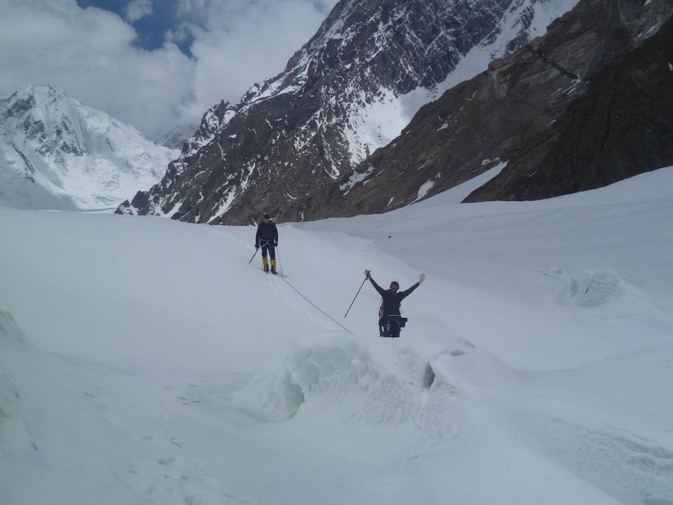
Day 6. Today we are moving by private transport of company to Askole. Askole is a high-mountain village, where civilization has not yet reached. There are no conditions for staying in hotels or guest houses. This is why we spend the first night in tents here. This is where the jeep road ends and we start walking to the top of K2. Today we are repacking the cargo and distributing it to the porters. Here, as many years ago, porters are still used to drop off cargo, rather than yaks and a helicopter, due to the weather and difficult terrain.
Day 7. on the seventh day we go to the track to the base camp. All our belongings are carried by porters. All we have in our backpacks is a wind jacket, spare dry thermal underwear, drinking water, snacks and washing accessories and bath Slippers. Since the caravan of porters goes at its own pace, we will only be able to see our back in the evening, so we will have to carry the above set of things along the way, and they will be very useful to us during the day. The entire team is divided into subgroups based on speed. Each subgroup is accompanied by a guide. Today we go to a camp called Jola, altitude 3200, the transition takes about 7 hours
I would like to draw Your attention to the fact that on the way to the base camp, all our food will be prepared by our expedition cook. We eat Breakfast in the morning. Fried sausages are usually served for Breakfast,
scrambled or boiled eggs, sliced cheese, oatmeal porridge or rice pudding. Drinks include green tea, black tea, herbal tea, or coffee.
For lunch-soup or borscht, buckwheat porridge, pasta, potatoes, wheat porridge, fried chicken, chicken with mushrooms, cutlets, steak, fish, pasta, pizza, fresh vegetable salads, vegetable stew and ajap sandal. Drinks include black, green or herbal tea, hot chocolate, cereal hot drinks, cookies, chocolate, coffee
On days when we have to go a long day, the cook gives participants and guides a pack lunch. There you can usually see a fried pie, boiled eggs, cheese and sausage-sliced.
For dinner, about the same set of dishes as for lunch. Also on birthdays, days of reaching the Top and national holidays, our chef will bake us a cake with cream.
Meals and accommodation throughout the route are included in the tour price.
Alcohol is not included in the price, so if you plan to use it, you need to take additional money.
Day 8. from the Jola Camp we move to the Payu camp, altitude 3400, the crossing takes about 7 hours
Day 9 Crossing from Payu to Urdukas, 3900, the crossing takes about 8 hours, a long day. The camp offers stunning views of the Baltoro glacier, Trango tower, Uli Biaho, Lobsang needles.
Day 10. Long-awaited rest and acclimatization
Day 11. Trek from Urdukas to Goro 2( 4200). All day we walk along the Baltoro glacier.
Day 12. Today we go from camp Goro 2 to camp Concordia (4500). A Pakistani military base is also located here. The camp is located on the gigant Concordia plateau. From here, we can see in all its glory our goal- the Mount K2-8611.
Day 13. The transition from Concordia to K2 Base Camp, the altitude of 5200.
NOW I WANT to WRITE ABOUT our BASE CAMP UNDER the top of K2 AND how LIFE WORKS IN IT.
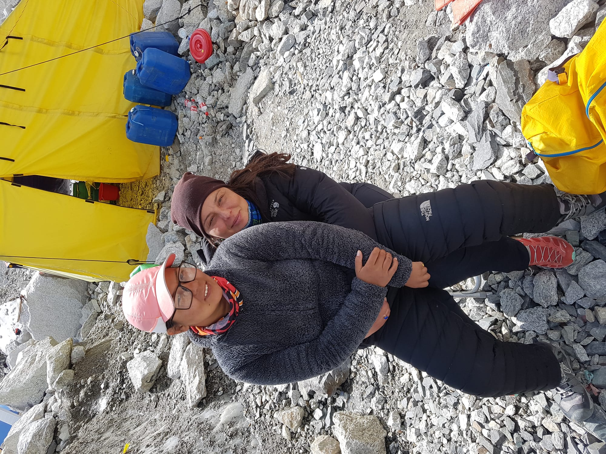
Base Camp under the K2 Summit will be our home for the next month. Now I will tell You about how life works in our Base Camp. Social life is concentrated in the dining tent, which is also the mess hall. This is a very spacious tent, the floor of which is covered with carpet. It is also equipped with a gas heater. That's why it's always warm. Even in the coldest weather. Usually all participants gather here, drink hot tea, chat, play cards or checkers, watch movies on a laptop.
Each participant receives an individual V-25 tent to stay in the Base Camp. If participants arrived as a couple, they can check in together. We have special tents for VIP service participants to stay in. These are large, stationary tents where you can stand at full height, measuring 2.5 x 3 m. The tent has an entrance hall, and the floor is covered with carpet. All tents without exception are equipped with sleeping mattresses.
Also in the Base Camp there is a tent, which is called a warehouse. You can put everything you don't need there.
Our shower room consists of two rooms. In the first room, you can change your clothes, leave dry clothes and towels. The second room is a shower room.
In the morning, in the bathroom there is always hot water for washing. Meals in the Base Camp are 3 times a day-Breakfast, lunch and dinner. Just always in the dining room on the table are thermos flasks with hot water, tea, coffee, chocolate, cookies. Participants can come there for tea at any time.
Day 14-17-Acclimatization with overnight stays at K2 Base Camp and Puja.
Upon arrival at the Base Camp under the K2 Summit, we will be here for 4 days. During these days, we will make acclimatization rotations and return to the Base Camp for the night. We will go up to the middle of the icefall 2 times, as well as descend towards broad Peak. A Puja will be held on one of these days. Puja is a worship service for successful ascent. At the same time, the consecration of the camp takes place. No expedition is sent up until this rite is performed. The Puja takes about 3 hours. During the monk's prayer, guides stretch a network of prayer flags over the Base Camp. According to an ancient tradition, flags should calm the elements, and thus provide a safe ascent and descent for climbers.
On the fifth day of our stay at K2 Base Camp, the first acclimatization exit will be planned.
Now I want to tell you what our participants carry in their backpack during high-altitude rotations and during the summit push. Most things, tents, food, high-altitude gas, oxygen, sleeping bags, all this is entered by high-altitude guides.
They also set up high-altitude camps. Participants carry their personal belongings, sunscreen, thermos of water, a powder puff, and a windbreaker. A personal guide will be attached to each participant for high-altitude exits. Participants of the VIP service will have two personal guides, and therefore they do not carry anything in their backpack at all. Guides take care of the safe passage of the route, prepare food for participants in high-altitude camps, and help with Jogging at high altitudes. Participants of the VIP service do not need to re - buckle at all-guides will do everything for them.
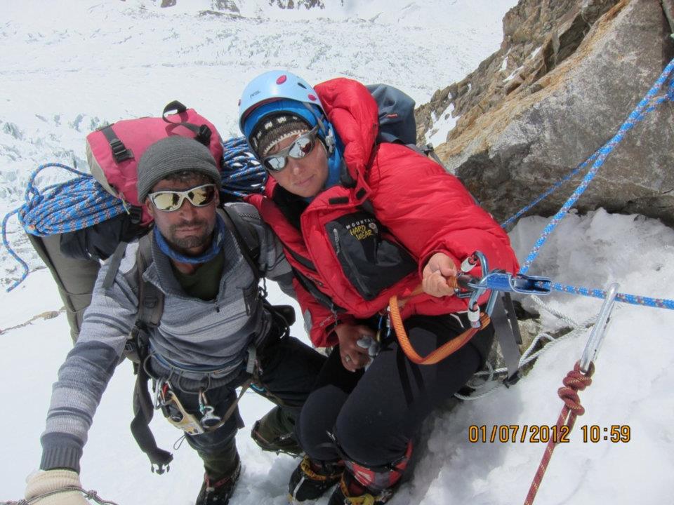
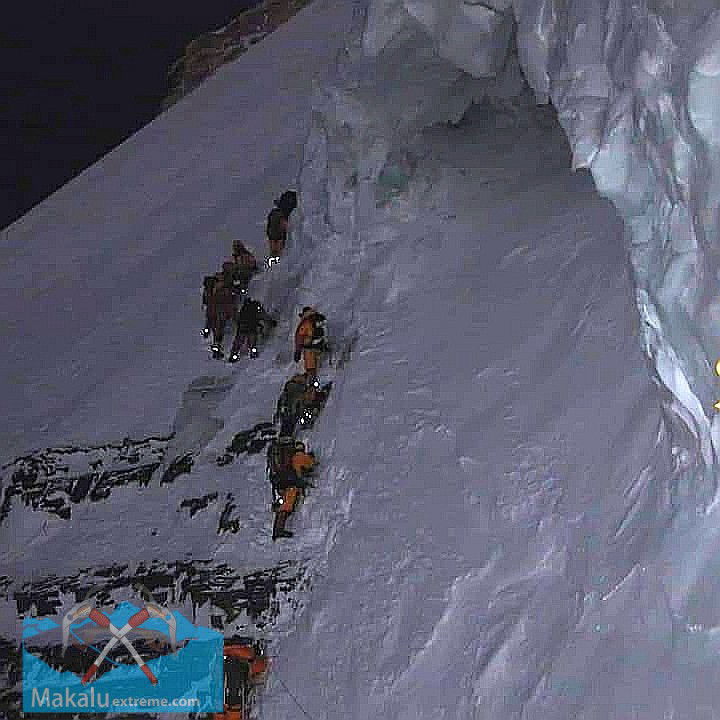
Day 18-Today we need to go up to Camp 1 at an altitude of 5800 meters. Our path passes first through a broken icefall, without a set height. The icefall is occasionally shot through by avalanches, so we leave no later than 2 am. At the end of the icefall, we rest on the moraine area. The site is called ABC. Next, go to the Abruzzi spur. Climbing along the spur has a rock-firn character. The spur is a rock hazard, so our task is to reach Camp 1 no later than 10 am.
Day 19-Camp 1 (5800) to Camp 2 6600. It's a grueling day, all day long challenging climbing and ladders. We need to overcome one of the key sections on the Mountain- Chimney house. Climbing, sections up to 90 degrees. The whole day consists of steps of fairly complex climbing. Here, many will need to gather their will and motivation in a fist. The passage of this section will take at least 8-9 hours for the average level of participants. Rope ladders are nailed to the most vertical sections for more acceptable passage, which are much more difficult to pass than iron ladders on the Khumbu icefall. Above the Chimney House on the shelf is Camp 2. here we spend the night. Accommodation in three-person V-25 tents for three people.
Day 20 - no later than 4 am we go down to the Base Camp. The start the descent is early, due to the objective rock hazard of the route.
Day 21, 22, 23 - stay at the Base Camp of K2.
Day 24-Camp 1 (6050), overnight
Day 25-Camp 2 (6700), overnight.
Day 26. Above camp 2 is a steep section called the Black Pyramid. Camp 3 is located on the shoulder of the Black pyramid. Above camp 3, avalanche-prone slopes go up. This camp is not completely safe, for this reason, we climb up to 7000 meters in the direction of Camp 3, and on the same day we descend to Camp 1. Overnight, tents V-25, accommodation for 3 people.
Day 27. Early in the morning, no later than 4 am, we start the descent to the Base Camp.
Day 28, 29, 30-Rest before the Summit Push. Depending on the weather, the rest can either be prolonged or very short. The weather in the K2 area is very unstable, and the weather window for an assault, at least three days long, is a great success.
Days from 31-to 43-depending on the weather, it will be Summit Push wether window sometime.
Day 31. And so, with God, we go out to the Summit Push! We go up to Camp 1 (6050)
Oxygen is another separate topic in the high-altitude expedition. According to our experience, we have included in the package the minimum number of cylinders required for safe ascent.
For a safe ascent, you need 5 oxygen cylinders. This is exactly the amount we have included in the package of our commercial ascent. The company will also give You a set of oxygen equipment to use. I want to remind you once again that 5 cylinders is the minimum amount of oxygen for a successful ascent. If you want to make your ascent, more comfortable and safe, you can buy oxygen at your own expense. The cost of 1 cylinder of oxygen is 700 dollars. I would like to draw Your attention to the fact that the readings on the fullness of the cylinder in Kathmandu and at an altitude of 7000 and 8000m on the pressure gauge will be very different due to the huge difference in atmospheric pressure. If you plan to use 5 cylinders, you can put on an oxygen mask no earlier than Camp 3 at an altitude of 7200 meters and you can only sleep when the water is supplied. If you use more oxygen than is provided, you will definitely not have enough oxygen to get to the Top and back. Therefore, in the oxygen issue, it is very important to assess your strength very soberly. We included 10 oxygen cylinders in the VIP package. Thus, VIP participants can use oxygen in the most comfortable mode. They can put on an oxygen mask at the foot of the Chimney house wall and use the oxygen supply 1 during sleep. Also, during the summit push, VIP participants will have enough oxygen to maintain a good climbing speed, which makes the Summit Push as safe as possible.
We leave for the Summit Push in the nearest weather window after acclimatization rotation. Each of our participants has a personal guide, and VIP service participants have as many as 2 personal guides. Therefore, each rope party of the participant- guide, will move in a convenient rhythm and mode for the participant. It is not necessary to wait for each other, especially since the participants of the full service and VIP service are initially in unequal physiological conditions in terms of the number of guides and oxygen.
Day 32. Camp 2 (6700)
Day 33. Camp 3 (7200). From Camp 2 to Camp 3-this is the most technical part of the ascent, 400 meters of almost vertical rock and ice climbing ( of course, railings will be fixed everywhere). Also, starting from this section, strong winds begin.
Day 34. We leave Camp 3 very early, at night, and move along the long snow slopes to Camp 4 (7900), Shoulder. It's still about 20 hours from Camp 4 to the Top. We immediately settle down to rest. Accommodation in V-25 tents for three people
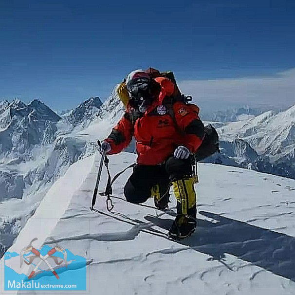
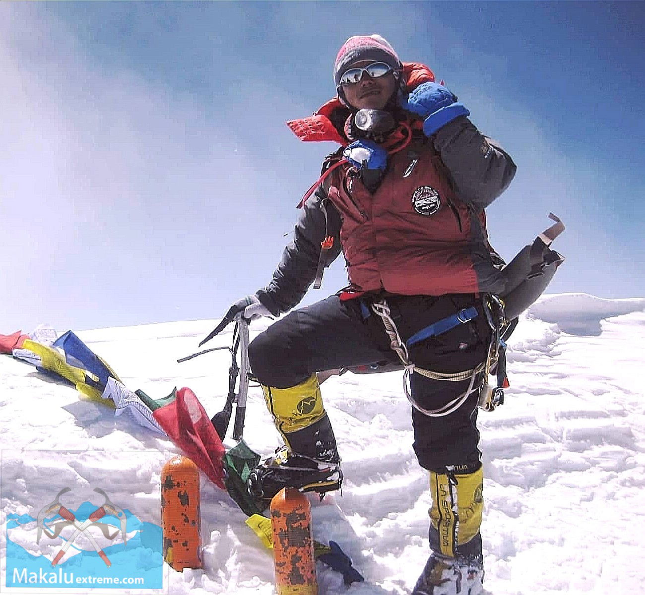
Day 35. The Summit push! Climbing to the Top of K2-8611, the Mountain of Mountains, the Dream of every climber!
We leave for the Summit Push at 8 PM. We will have to overcome at an altitude of 8300 one of the most dangerous keys of the route - Bottle neck, a 100 - meter, almost vertical rock - ice couloir. Behind the couloir, we get to a steep summit slope, which we climb to the Summit. For the fastest participants, who also have a good amount of oxygen, the section from Camp 4 to the Top of K2 will take at least 10 hours, for the slowest participants, the Summit ascent may take 18 hours. You should always remember that according to the rules of our company, the return point is 12 AM. Wherever You are, at 12 o'clock in the afternoon, you must turn back, even if you are 100 meters away from the Top. This is the main rule of the Mountains, and it is written in blood, those who did not return ... Well, the lucky ones who succeeded in this assault, already take photos on the Summit of K2. A few photos for memory and down to Camp 4!
Day 33. Again, very early start to descent, no later than 4 am, and down to Camp1
Day 34 Base Camp
Day 35 Rest
Day 36 Packing and collecting cargo
Day 37-42-Return to Islamabad
Day 43-Free day in Islamabad
Day 44-Home
Day 44-55-Spare days for bad weather