The Everest 8848 climbing expedition introduction
www.makaluextreme-treks-expeditions.com
Whats App +7-918-104-23-18
All about the Everest 8848 climbing expedition
Expedition-tour " Everest 8848 climbing expedition" - autumn 2020-spring 2021.
Dear friends! Autumn is approaching, and with it our expedition Everest 8848 - Lhotse 8516. Now we have confidence that it will take place. You still have time to join our expedition. That's why I decided to describe in detail how we are going to climb mount Everest. Today I will tell you all about the Everest climbing expedition
Today, my story is about the Mount Everest 8848 climbing expedition, about our services and what our participants pay $ 36,000 for full service and$ 48,000 for VIP service. I would like to draw Your attention to the fact that the services provided and their quality strictly correspond to this description.
Short information
 Everest 8848 is a mountain in the Himalayas, the highest Peak of our planet, the Roof of the World. The peak is located in the Mahalangur-Himal range, which runs along the border of Nepal and the Tibet Autonomous region (China).Everest has the shape of a three-sided pyramid, the southern slope is steeper. On the southern slope and edges, the snow and firn are not held, so they are exposed. The height of the North-Eastern shoulder is 8393 m. The height from the bottom to the top is about 3550 m. The top consists mainly of sedimentary deposits.
From the South, Everest is connected by the South Col pass (7906 m) with Lhotse (8516 m), sometimes called the South peak. From the North, the steeply sloping sharply sharpened North Col (7020 m) connects Everest with the Northern peak — Changze (7553 m). To the East, the impassable Eastern wall of Kangshung (3350 m) ends abruptly. Glaciers flow down from the massif in all directions, ending at an altitude of about 5000 m.
Jomolungma is partially part of the Sagarmatha national Park (Nepal).
THE CLIMATE ON EVEREST
The average daily temperature at the top of Jomolungma in July is about -19 °C, in January -36 °C (and can fall to -60 °C). Since the height of the peak is almost at the lower limit of the high-altitude jet stream, sudden storms with wind gusts up to 160 km/h are quite typical. Precipitation falls as snow during the summer monsoon, which lasts from late may to mid-September
MOUNTAINEERING ON EVEREST
Everest is the highest peak of the Earth, which attracts a lot of attention of climbers; attempts to climb are regular.
The ascent to the top takes about 2 months - with acclimatization and installation of camps. Weight loss per ascent-an average of 10-15 kg. Countries where there are approaches to the top, take a fee not only for climbing it, but also for a number of mandatory services (transport, communications officer, translator, etc.). the order of ascent of expeditions is also Set. It is cheaper to ascend Jomolungma from Nepal on the classic route from the South (data on climbing Everest in mountaineering groups for 2020-2021)
 The main season of climbing to the top is spring and autumn, since there are no monsoons at this time. The most suitable season for climbing the southern and Northern slopes is considered to be spring. In autumn, you can only climb from the South.A significant part of the ascents are organized by specialized companies and performed as part of commercial groups. Clients of these companies pay for the services of guides who provide the necessary training, equipment and, as far as possible, ensure safety along the way. The cost of climbing is from 35 to 120 thousand US dollars, and the climbing permit issued by the government of Nepal alone costs 13 thousand dollars.
In the XXI century, thanks to the development of tourist infrastructure, there is a significant increase in annual ascents: so, if in 1983 the top reached 8 people, in 1990 — about 40, in 2012 only one day on Everest climbed 234 people, and in 2020 443 people visited the Peak on the peak day of the Climbing season. During the ascent, there were many hours of traffic jams and even fights between climbers.
The success of the expedition depends directly on the weather and equipment of commercial climbers. Climbing Jomolungma continues to be a serious challenge for everyone, regardless of their level of training. Acclimatization before climbing mount Everest plays a significant role. A typical southern expedition spends up to a week climbing from Kathmandu to the base camp at an altitude of 5364 m, and it takes about a month to acclimatize to the altitude before attempting to climb to the top.
The most difficult part of the ascent of mount Everest is the last 300 m, which is called by mountain climbers "the longest mile on Earth". To successfully pass this section, you need to overcome the steepest segment, nicknamed "Hillary's Step", covered with dry snow.
 THE HISTORY OF CLIMBING ON EVEREST
Until the first ascent of the peak, which took place in 1953, there were about 50 expeditions to the Himalayas and Karakoram (to Jomolungma, Chogori, Kanchenjunga, Nangaparbat and other peaks). Climbers managed to climb several seven-thousand-meter peaks of these mountain areas, but no attempt to storm the peaks of the eight-thousand-meter peaks was successful. In 1950, the French managed to climb the first eight — thousand-meter peak-Annapurna.
English climbers have achieved the greatest result when trying to climb mount Everest, thanks to the use of oxygen. The 1921 exploration expedition was followed by the 1922 expedition in which George Finch and Geoffrey Bruce reached an altitude of 8320 m, using oxygen for the first time. In 1924, Norton reached a height of 8565 m, and George Mallory and Andrew Irwin (as estimated By N. Odell) — more than 8,600 m. According to some reports, they were last seen alive 150 meters from the top (through binoculars, in a break in the clouds). There is a version that they died while descending from the top; and the debate about whether they reached it or not continues today. Mallory's body was discovered in 1999. In 1933, P. Win-Harris, L. Wager and F. Smith reached an altitude of 8565 m. In 1934, the eccentric Maurice Wilson, who had no special mountaineering training and believed that he would be lifted to the top by supernatural forces, died at an altitude of about 7 km, although later it was sometimes believed that he broke a tent found by later expeditions at an altitude of 8.5 km. The following British expeditions were undertaken in 1936 and 1938. In 1947, the canadian Earl Denman with two Sherpas could only climb up to 6.7 km.
Mountaineers of expeditions before 1949 tried to ascend to the highest point of the planet from the North, from the side of Tibet, because the territory of Nepal was closed to Europeans until 1948. The first exploration of mount Everest from the South, from Nepal, was undertaken by British climbers in 1949. In 1950, Tibet was effectively closed to Europeans.
Edmund Hillary in 1953
The first ascent was made on may 29, 1953 by Sherpa Tenzing Norgay and New Zealander Edmund Hillary through the South Col-on the path explored the day before by the Swiss. The climbers used artificial oxygen. More than 30 Sherpas took part in the expedition.
In the following years, the highest peak of the world was conquered by climbers from different countries — the United States, the USSR, China, India, Japan, Italy and other countries.
May 1, 1963-Jim Whittaker Jim Whittaker) became the first American climber to set foot on the top of mount Everest. Three weeks later, a second group from the same American expedition made an even more stunning ascent — the first ascent of the previously unconquered Western edge of mount Everest.
In the spring of 1975, Everest was first stormed by a women's expedition. The first woman to conquer jomolungma was Japanese mountaineer Junko Tabei in 197). The first European woman to reach the top was Polish Wanda rutkiewicz in 1978. The first Soviet climber to reach the summit was Ekaterina Ivanova in 1990.
On September 24, 1975, a British expedition led by Chris Bonington first passed the Southwestern wall of mount Everest. Doug Scott and Dougal Haston reached the top. Two days later, on September 26, Peter Boardman and Petemba Sherpa repeated their journey to the summit. Mick Burke, who was following them, was missing.
In the following years, climbers from great Britain, Nepal, the USA, South Korea, Austria and Germany ascend mount Everest again along the classic path of the first ascenders, with Reinhold Messner and Peter Habeler reaching the summit without using oxygen throughout the entire assault. As part of these expeditions, two more women — Polish Wanda rutkiewicz (1978) and German Hannelore Schmatz (died during the descent) — managed to conquer Everest. French-Jean Afanasief and N. Zhezhe went down on skis from 8 km to 6.5 km.
The poles managed to say a new word in climbing to the top under the leadership of Andrzej Zavada. They were the first in the world to climb to the top of mount Everest in winter. This ascent was made by Leszek Cichy and Krzysztof Wielicki. The ascent was carried out on the South-Eastern ridge at temperatures below -50 °C on the last day of the validity of the local authorities ' permission to storm the summit. A few months later (in the spring of 1980), the poles, led by the same A. Zavada, laid a new route to Everest. Andrzej Chok and Jerzy Kukuczka climbed to the top of the southern buttress
As a rule, all climbers climb mount Everest in oxygen masks. At an altitude of 8 km, the air is thin, and it is very difficult to breathe. The Italian Reinhold Messner and German Peter Habeler were the first to reach the summit without oxygen in 1978.
In 1980, Reinhold Messner, this time alone, again climbed mount Everest and set several records at once. Messner was the first to reach the summit alone without oxygen, without the help of high-altitude porters. In addition, he was the first to dare to challenge Everest during the monsoon and reached the goal. In addition, he overcame the path from the base camp, located at an altitude of 6.5 km, to the top of the new version of the path from the North in just 3 days.
 RECORDS
In May 2001, French snowboarder Marco Siffredi was the first to descend from the top of mount Everest on a snowboard from the Norton Couloir. The descent to the base camp took 2.5 hours. A year later, in the fall, Marco made a second ascent of mount Everest to snowboard down the Hornbine Couloir. After the ascent, the snowboarder started down the Hornbine Couloir alone, and was never seen again.
In 2001, an amazing ascent of mount Everest was made by a blind American, Eric Weichenmeier. By that time, he had already conquered all the highest mountain peaks on all continents. "By climbing the seven highest mountains in the seven parts of the world, I hoped to show people that goals that may seem unattainable are actually quite achievable," Weichenmeier said in a statement.
On May 21, 2004, Pemba Dorje (Speed Pemba) set a record for the fastest ascent of mount Everest: 8 hours and 10 minutes from the base camp near the Khumbu glacier.
On May 22, 2010, Jordan Romero, a 13-year-old American, climbed the summit with his father. Before that, the record was held by 15-year-old Min Kipa Sherpa.
In May 2011, the Nepalese spiritual master Bhakta Kumar Raibil set a new record for the longest stay at the top — 32 hours.
On May 12 and 19, 2012, a Nepalese woman named Chhurim set a record by climbing mount Everest twice in a week.
On May 23, 2013, 80-year-old Japanese Yuichiro Miura completed the ascent and became the oldest person to reach the top of mount Everest. Before that, the record was held by a 76-year-old Nepalese named Min Bahadur Sherhan
On May 24, 2014, an Indian girl, Purna Malavath (13 years, 11 months), won the summit. The ascent took place from the North side along a standard route using oxygen cylinders and the help of Sherpas. Purna became the youngest woman in the history of climbing Everest.
On May 25, 2014, a 72-year-old American mountaineer, bill Burke, climbed to the top of mount Everest on the standard route from the North side. Earlier, on may 23, 2009, bill had already climbed mount Everest at the age of 67 (the ascent took place on the standard route from the South side). Thus, Burke is the oldest climber who climbed Everest from both sides (the ascents were conducted at the age of more than 65 years).
On May 21, 2019, Nepalese mountaineer Kami Rita Sherpa set a world record for the number of successful ascents to the summit — 24 times (23 times he climbed from the southern, Nepalese side and 1 time from the Northern, Tibetan side). The ascents were made between 1994 and 2019.
 And now, Dear friends, let's talk about our tour “Everest climbing expedition”
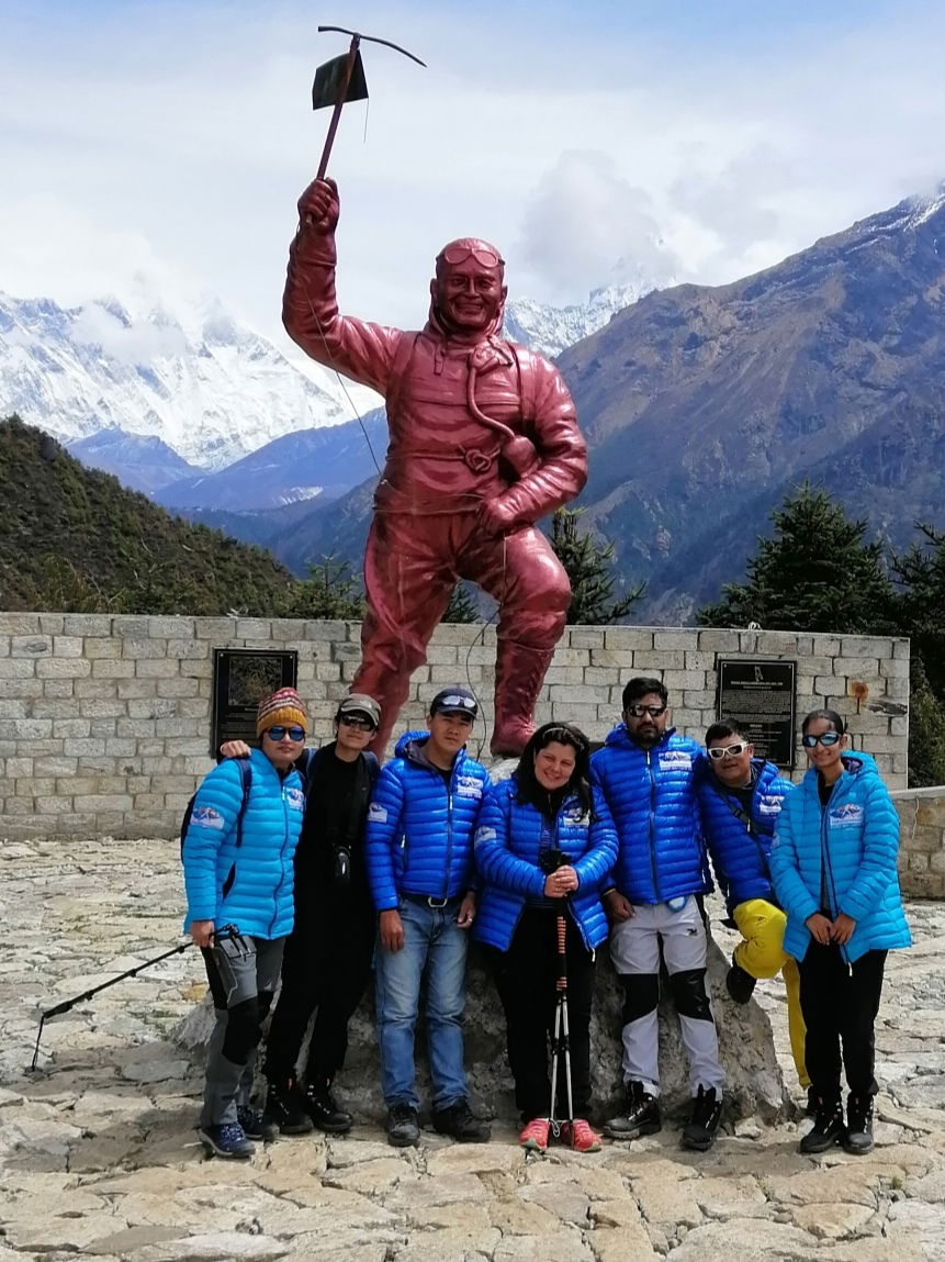
The first is why you should come with us. Here everything is very simple. You will work with Pasang Lama and Pasang Dorji Sherpa as the main guides, and I and Dorchi Sherpa as the organizers. We have our experience on our team-25 ascents to the Top of mount Everest. Let me explain-Dorchi Sherpa (organizer)- 9 Ascents, Pasang Dorji Sherpa (guide) - 5 ascents, Pasang Lama-11 ascents. You can conclude that you simply can't find a team that knows this Mountain like we do. And also, our mountaineering is still commercial, so we try to minimize stressful and uncomfortable situations on the Mountain for OUR participants. We hold the lives of our participants in our hands, and we are very much aware of our responsibility.
How is our tour going?
Our not virtual introduction starts at the international airport Tribhuwan. We personally-I, Dorchi or Pasang Lama meet You at the airport with the logo of our company. The transfer can be individual, or it can be a group, if you suddenly
arrive at the same time with one of the participants. It takes about 20-30 minutes to get from the airport to the tourist center of Thamel, where our hotel is located. Our groups stay in a comfortable hotel decorated in the local national style. The rooms are equipped with hot and cold water, air conditioning, and water glasses. Participants of the "Full Service" program have accommodation for 2 people in a room. VIP program participants have accommodation in VIP rooms, single accommodation. The package Price includes 4 nights in a hotel.
The next day, very early in the morning, We go to the Seto Gompa monastery for Puja. This is one of the largest monasteries in Kathmandu with ancient traditions. Puja is a worship service for successful ascent to the Top. According to local traditions, no expedition begins without this rite and the blessing of the Supreme monk. After the Puja, we return to the hotel. Participants have free time - you can buy what you may need in the Mountains.
The next day we have an early check-out. We go to Phaplu or Ramechap airport to fly from there to Lukla by private company transport. Only expedition participants and accompanying guides are allowed in a jeep or minibus. The decision where we will fly from is made about a month before the start of the expedition, depending on the flight schedule. But, if possible, of course, we prefer flights Phaplu - Syangboche. We will describe this standard version here. And so, at about 3 PM, We arrive in Phaplu and check in at the airport hotel. Phaplu is a village in the mountains in Solukhumbu district at an altitude of 2430 meters. Phapiu was the first airport to be built in the region. A social project called the airport in Phaplu was led by Edmund Hilary. The airport was built in October 1976.
The organizers buy fresh vegetables for the expedition, and the participants can take a guided tour of the surrounding area.
 The next morning, we fly to Syangboche. Syangboche is located at an altitude of 3500 m above the sea level. The flight takes about 15 minutes. After arriving in Syangboche, we descend to Namche Bazar, at an altitude of 3400 Meters. We will spend 2 nights there for acclimatization. We are staying at Jamling's hotel. This is a very clean hotel with excellent cuisine. As before, full service members live for 2 people in a room, and VIP members - in single VIP rooms. I would like to focus on the description of the village of Namche Bazar separately. It is very clean, consisting of modern hotels and shelters, bekkari and pubs, a mountain village. Namche Bazar is the capital of the Sherpas. The village is surrounded by huge Himalayan Mountains. It has its own unique and unforgettable atmosphere. Anyone who has been here at least once, always wants to return here. The price level here is average, and erroneous information is given in the network that everything is supposedly cheap here. However, our tourists ' package includes accommodation and food, so if you take extra money here, it is for Souvenirs and visiting pubs.The village is very famous for tourists and climbers, because it is located on the road to Everest and has an expanded system of tourist hotels, restaurants, shops where tourists can relax and prepare for the hike. There is electricity in the village, and the Syangboche airport (helicopter station) is located nearby, but most tourists cannot use It: due to the protest of local residents, Lukla airport (located about 13 km South of Namche) is used for mass tourism. From the airport to Namche Bazaar, tourists must make a daily transition (in the case of a very fast walk, six hours is enough). Servicing tourists on this site provides employment and income to local residents.
Namche Bazar is also home to official institutions, police control, a post office, and a Bank. The Nepalese army barracks are located at the top.
Namche-Bazar is the main point for traveling to Everest, to the mountain and lake Gokyo.
Above the village is the base of the Sagarmatha National Park, which offers views of mount Everest and other mountain peaks.
At an altitude of 3800 above Namche Bazar, the Everest view hotel is a luxury hotel with a terrace where you can see mount Everest in good weather. The hotel organized trips for rich tourists, but many experienced acute mountain sickness from the sudden ascent to such a height. The hotel is additionally equipped with a dome and oxygen supply of rooms.
 On Saturdays, the market opens in the morning, which attracts residents of the surrounding villages, as well as Tibetans who come with goods through the passes from Tibet with Chinese goodsThere are several Tibetan monasteries in the vicinity of Namche Bazar.
In the late 1980s and early 1990s, a small hydroelectric power station "Thame-Namche Bazar" with a capacity of 620 kW (two bucket turbines of 310 kW each) was built with the financial assistance of Austria to electrify the village and the nearby settlements of Khunde, Kumjung, and Thamo)
The village is located at an altitude of 3440 m on a side slope of a hill.
According to the 1991 census the village had 1647 inhabitants in 397 households
To the West of Namche Bazar is mount Kongde-Ri, 6187 m high, and to the East is mount Thamserku, 6623 m high.
The first day in the village we will make a trekking tour around the village. On the second day, we will go to the village of Syangboche and to the observation point. We spend the second night in the same way, in Namche Bazaar.
The next day we go further, in the direction of the Base Camp. Overnight in the village Deboche. From the pass Syangboche first time, views of Lhotse and Everest. From here, we see our goal in full view for the first time. It is a 6-hour walk from Namche Bazar to Diboche. The path first goes down to the river, and then rises again to the hill where the monastery of Tiangboche is located. The altitude here is 3900 m. We visit the monastery and get the blessing of the monks to ascend. You can bed down in the village Deboche. We spend the night in a beautiful place, a lodge called AMA Dablam Lodge. This is one of the oldest and most comfortable lodges in the area with its own traditions.
 The next day brings us to the village of Dingboche. It's not a very long day with a very gentle climb. The village is located at an altitude of 4300. Here we will spend another night for acclimatization. For acclimatization, we go up to the acclimatize point 5400 the next morning, and then return to the hotel again.And so, we are only two days away from Base Camp.
We leave not very early, having had a good night's sleep. It's not far to go today. We have to climb to the village of Lobuche at an altitude of 4600 meters. We check in at a hotel called oxygen, which means Oxygen. This is a very comfortable hotel for these conditions. The dining room is very hot and heated, even when it's freezing outside.
The next day, the transfer from Lobuche to the Base Camp. This is an early exit, since the entire journey will take
about 6 hours. Our base Camp is located deep in the Khumbu glacier, just before the beginning of the railings that lead to the Khumbu icefall. Upon arrival at the Base Camp, we are already waiting for a wonderful lunch and a warm dining tent. Our dining tent is heated by a gas heater, so it is much warmer than outside.
What do our participants carry in their backpack during the day?
Our participants carry a bottle of water or thermos of tea, sunscreen, spare gloves, Windproof jacket, down jacket. All other things are transported by yaks in our caravan. The baggage allowance that a participant can give to the caravan is 30 kg per person for full service participants and 60 kg of cargo for VIP service participants.
I would like to draw Your attention to the fact that on the way to the base camp, all our food will be prepared by our expedition cook. We eat Breakfast in the morning. Fried sausages are usually served for Breakfast,
fried or boiled eggs, sliced cheese, porridge or rice pudding. Drinks include green tea, black tea, herbal tea, or coffee.
For lunch-soup or borsch, buckwheat porridge, macaroni, potatoes, wheat porridge, fried chicken, chicken with mushrooms, cutlets, steak, fish, pasta, pizza, salads from fresh vegetables, vegetable stew and ajap sandal. Drinks include black, green or herbal tea, hot chocolate, cereal hot drinks, cookies, chocolate, coffee
On days when we have to go a long day, the cook gives participants and guides a pack lunch. There you can usually see a fried pie, boiled eggs, cheese and sausage-sliced.

For dinner, there is about the same set of dishes as for lunch. Also on birthdays, days of reaching the Top and national holidays, our chef will bake us a cake with cream.
Meals and accommodation throughout the route are included in the tour price.
Alcohol is not included in the price, so if you plan to use it, then you need to take additional funds.
Base Camp will be our home for the next month. Now I will tell You about how life is arranged in our Base Camp. Social life is concentrated in the dining tent, which is also the mess hall. This is a very spacious tent, the floor of which is covered with carpet. It is also equipped with a gas heater. Therefore, it is always warm. Even in the coldest weather. Usually this is where all the parties, drinking hot tea, talking, playing cards or checkers, watching movies on the laptop.
To stay in the Base Camp, each participant receives an individual tent V-25. If the participants arrived as a couple, they can check in together. For VIP service participants, we have special tents for accommodation. These are large, stationary tents where you can stand at full height, measuring 2.5 x 3M. The tent has an entrance hall, and the floor is covered with carpet. All tents without exception are equipped with sleeping mattresses.
Also, in the Base Camp there is a tent, which is called a storiggehouse. You can put all the extra stuff in there.
Our shower room consists of two rooms. In the first room, you can change your clothes, leave dry things and towels. The second room is, directly, a shower room.
In the morning, there is always hot water in the washbasin for washing. Meals at the Base Camp are 3 times a day - Breakfast, lunch and dinner. Just always in the dining room on the table are thermos flasks with hot water, tea, coffee, chocolate, cookies. Participants can come there for tea at any time.
Upon arrival at the Base Camp, we will stay here for 4 days. During these days, we will make acclimatization exits and return to the Base Camp for the night. We will go up to the middle of the Khumbu icefall and climb Kala Patar 2 times. On one of these days, a Puja will be held. Puja is a worship service for successful ascent. At the same time, the camp is consecrated. No expedition is sent up until this rite is performed. Puja takes about 3 hours. During the monk's prayer, the guides stretch a network of prayer flags over the Base Camp. According to ancient tradition, flags should calm the elements, and thus ensure a safe ascent and descent for climbers.
On the fifth day of our stay at the Base Camp, the first acclimatization trip will be planned.
Now I want to tell you what our participants carry in their rucksacks during high-altitude exits and during the Everest Summit Push. Most things, tents, food, high-altitude gas, oxygen, sleeping bags, all this is entered by high-altitude guides. They also set up high-altitude camps. Participants carry their personal belongings, sun cream, thermos of water, a puffer jacket, and a windbreaker. A personal guide will be attached to each participant for high-altitude exits. Participants of the VIP service will have two personal guides, and therefore they do not carry anything in their backpack at all. Guides take care of the safe passage of the route, prepare food for participants in high-altitude camps, and help on runs at high altitudes. VIP service participants do not need to fasten themselves at all - guides will do everything for them.
During this rotation, we will have to cross the Khumbu icefall and climb to Camp 1, and then the next day to Camp 2. The next day we will go up about 300-400 meters in height in the direction of L 3 and go down for the night in L2. The next day we go down to the Base Camp. Walking through an icefall is a very exhausting story. Therefore, we will need at least three days to recover from the high-altitude rotation. And then we will again be waiting for acclimatization rotation. We cross the Khumbu icefall again, go up to Camp 1, the next day to Camp 2, the next day to Camp 3. We spend the night in camp 3. In the morning we go down to Camp 2, the next morning to the Base Camp. Now we need to recuperate, and we are ready for the assault. Now we will choose the appropriate weather window. The Base Camp has an Internet connection from the provider Everest Link, so we are constantly able to receive updates of the weather forecast.
Oxygen is another separate topic in the high-altitude expedition. According to our experience, we have included in the package the minimum number of cylinders required for safe ascent.
For a safe ascent, you need 5 oxygen cylinders. This is exactly the amount we have included in our commercial climbing package. The company will also give You a set of oxygen equipment for use. I want to remind you once again that 5 cylinders is the minimum amount of oxygen for a successful ascent. If you want to make your ascent, more comfortable and safe, you can buy oxygen at your own expense. The cost of 1 cylinder of oxygen is 500 dollars. I would like to draw Your attention to the fact that the readings on the filling of the balloon in Kathmandu and at an altitude of 7000 and 8000m on the pressure gauge will differ greatly due to the huge difference in atmospheric pressure. If you plan to use 5 cylinders, then you can wear an oxygen mask no earlier than Camp 3 at an altitude of 7200 meters and you can only sleep when you feed 0.5. If you use more oxygen than you are supposed to, you will definitely not have enough oxygen to get to the Top and back. Therefore, in the oxygen issue, it is very important to assess your strength very soberly. We included 12 oxygen cylinders in the VIP package. Thus, VIP participants can use oxygen in the most comfortable mode. They can put on an oxygen mask already at the foot of the LHOTSE FACE wall and use oxygen on feed 1 during sleep. Also, during the Everest Summit Push, VIP participants will have enough oxygen to maintain a good climbing speed, which makes the Summit Push as safe as possible.
We leave for the Everest Summit Push in the nearest weather window after acclimatization rotation. Each of our participants has a personal guide, and VIP service participants have as many as 2 personal guides. Therefore, each group of participants-guides will move in a convenient rhythm and mode for the participant. It is not necessary to wait for each other, especially since the participants of the full service and VIP service are initially in unequal physiological conditions in terms of the number of guides and oxygen.
When participants rest between high-altitude rotation, their guides continue to work. They build and equip a network of high-altitude camps. Thus, when we go to the Summit Push, the entire infrastructure of high-altitude camps is already ready. According to the laws of the community on the Mountain, only the company that owns them has the right to use the grounds for high-altitude tents and tents on them in any circumstances. This is very true, since the construction of Camps is really a very difficult and financially costly operation. The work of a qualified guide at these heights is very expensive and all these payments fall on the shoulders of the organizer.
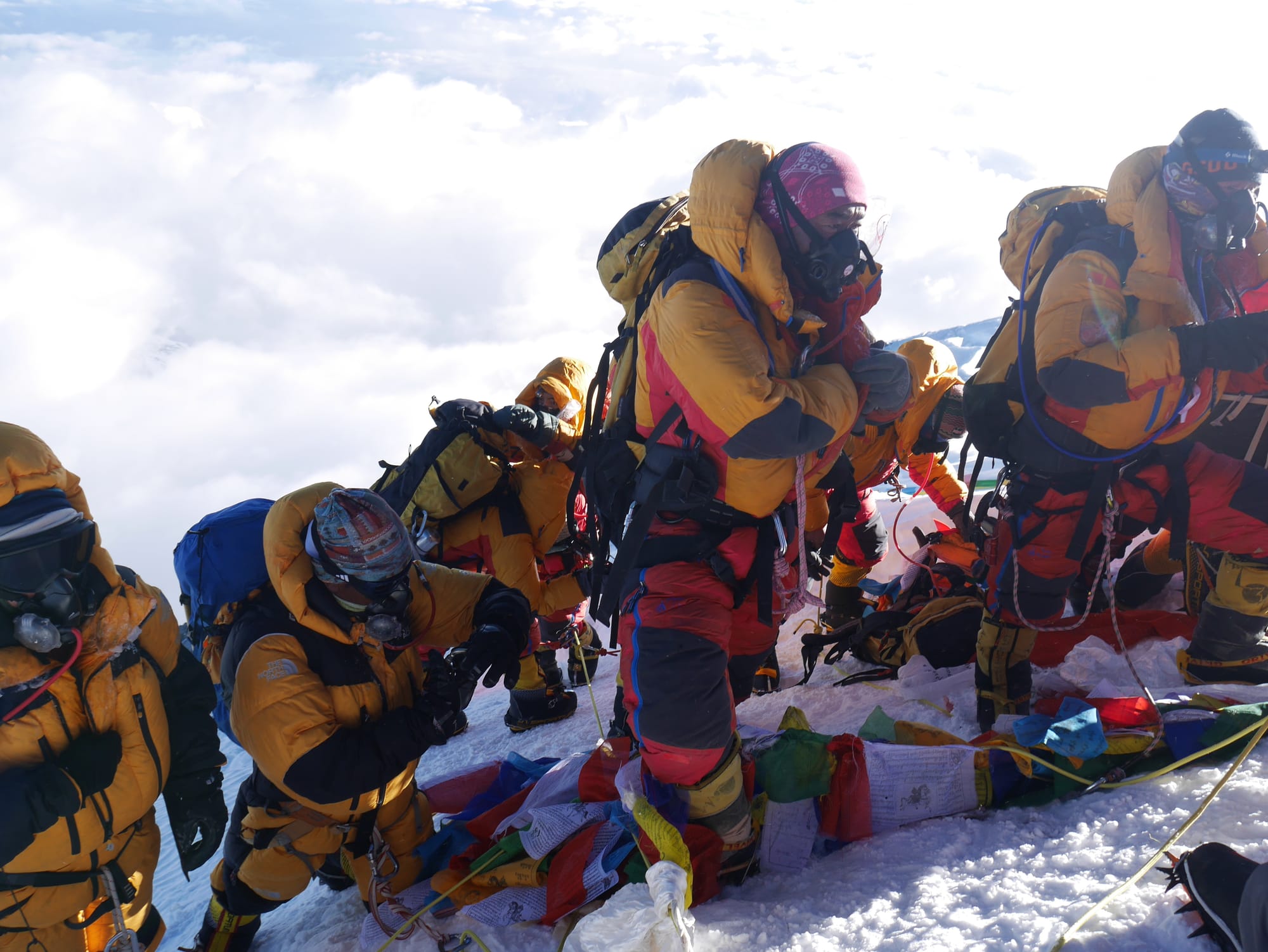
And so, we went on the Summit Push. Each bundle of the guide-participant moves at its own pace. The start from Base Camp to Camp 1 is usually no later than 12 am, as it is desirable to pass the collapse of a dangerous icefall at night. Further, the other outputs may be later. I also want to pay attention to the section camp 3-Camp 4. in the area of the yellow belt, the route can be very dangerous on a Sunny day, so, again, it is necessary to go out on this section early.
And so. We have reached the South Col and are going out at Night to Attack!
We leave Camp 4 for the Summit Push no later than 10 PM. If the participants are slow, we leave at 8 or 6 PM. During the Summit Push, the participants only have a thermos with hot tea in their backpack and one oxygen cylinder, from which the participant directly breathes. Even a very well-prepared person will need at least 7 hours to Climb to the Top of mount Everest, and at least 3 hours to descend to Camp 4. for average physical training, this time, of course, will be longer, for slow participants, the Summit Push may take about 13 - 14 hours only to the Top. And about 20 hours South Col-Top - South Col.
South Col: 8016 meters
Welcome to the Dead zone! It is a flat plateau covered with loose scree and surrounded by mount Everest in the North and Lhotse in the South. Almost always there is a hurricane wind. As a rule, teams put their tents close to each other and are secured with heavy stones, as well as wrap around the top of the tent with auxiliary ropes, because here, in an open area, the tent can be torn down by a gust of wind.
This is an intermediate platform for the start of assault ascents to the top, a shelter where you can rest and recover.
Mark Balcony ("the Balcony"), 8400 meters, approach time from the South saddle from 3 to 6 hours
Here the rate of ascent is terribly slow, there are many rest stops, and the decision is made whether to continue climbing or go back down. Depending on the weather, it can be like snow or bare rocks. Rocky areas can become a big problem and threaten rockfalls, so some climbers now use hard hats. At this point, climbers change their empty oxygen tanks for new ones and take a short break for a meal.
South summit, 8690 meters, climbing time from Balconies from 2 to 6 hours
The climb from the balconies to the southern top is quite steep, with no suitable places to rest. This is the most technically difficult part of the ascent. Especially when a large number of people gather on the route. On the other hand, it offers the best view of Lhotse
Hillary Step, 8790 meters, approach time from the southern peak is about 1 hour
The Hillary step is an almost vertical rock slope with a height of 13 m, which is a narrow snow-ice ridge with steep cliffs on the sides.
It is located at an altitude of 8790 m on the South-Eastern ridge of the mountain half way from the southern summit to the main summit of Everest. Named in honor of the pioneer of Everest Edmund Hillary.
This is one of the most open steep sections of the ascent, where you need to traverse the ledge between the top and the Hillary step. But this section of the route is suspended by railings and is quite wide, so that most climbers do not have difficulties.
After the 2015 earthquake, the Hillary step changed, and by 2017 it had partially collapsed.
Previously, there was a short two-meter vertical section of rock climbing, with fixed railings, which created a bottleneck for the crowds of climbers.
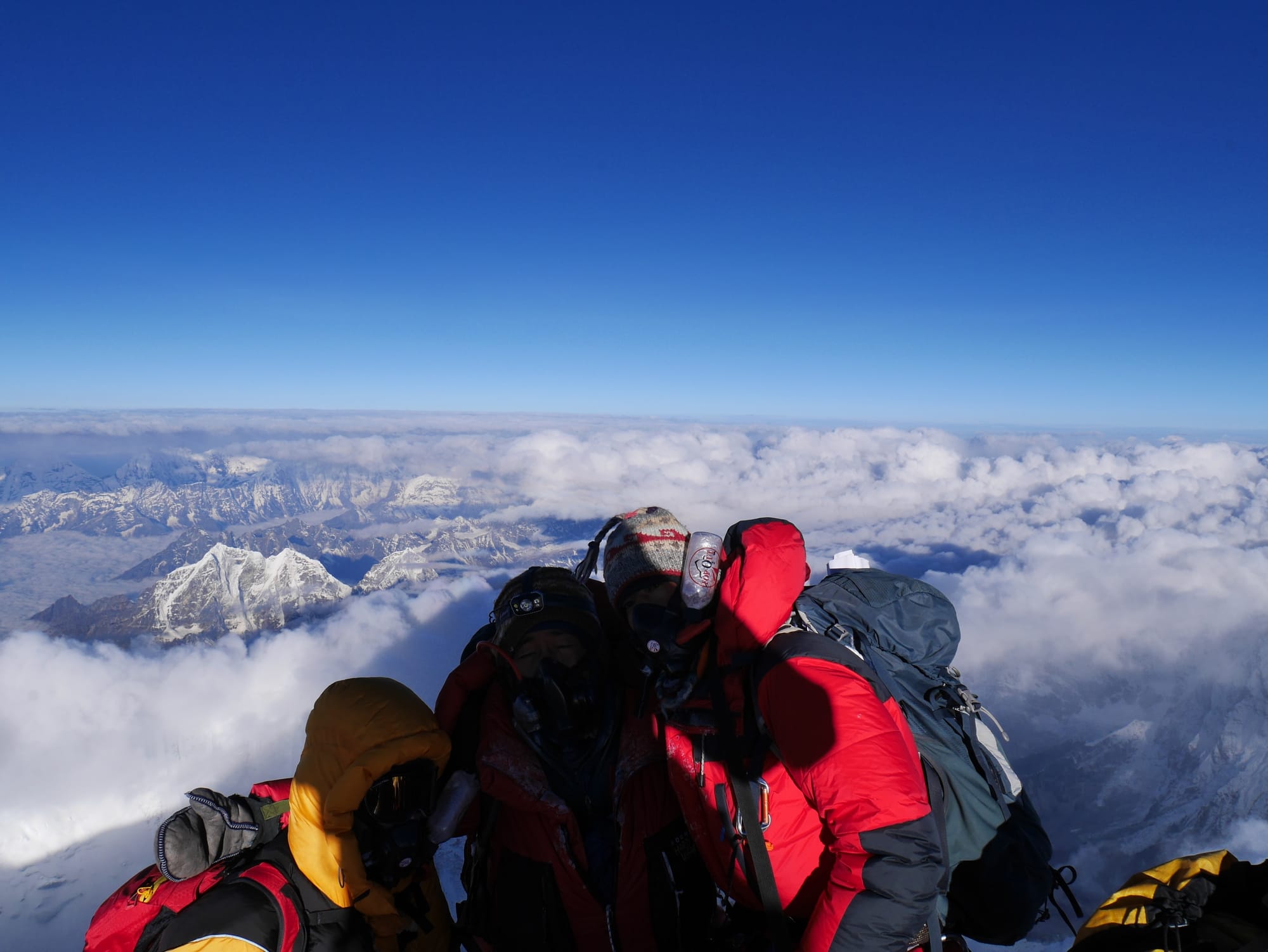
On the way up, we can see the most incredible views in the Himalayas. The top of mount Everest is the place where a Dream comes True, and, in a few hours, a Dream again.
From the Top we go down to Camp 4 or 3, which everyone chooses according to the state and amount of oxygen.
Next day - the descent in L2, and the following day descend to base camp. At the Base Camp, we will have a festive dinner, cake, and a hot shower. The next day we rest and pack cargo. And finally, the next day we leave the Base and go down. The descent takes place on the way up. We also stay in the same hotels as at the beginning of the expedition.
In Lukla's Airport, we say Goodbye to the Himalayas.
In Kathmandu, participants have another free day to buy Souvenirs, banquets and excursions.
The next morning we escort the participants to the airport. We, the organizers, hope to see our participants in our next expeditions, because there are 14 eight-thousand mountains on Earth!